

Ocean City and Assateague Island
 I left home at 1:30 a.m. in order to give myself more than adequate time to reach my scheduled boat tour in Ocean City, Maryland. This was an impulse trip just because I hadn’t been to OC yet and had the opportunity for a relatively inexpensive trip that included about a 4.5-hour drive each way. The weather forecast a partly cloudy day with temps reaching the mid-60s. I dressed in a long-sleeved shirt and knee-length sweatpants, then opted for a hooded sweater instead of my jean jacket (BIG mistake).
As I drove out, I wondered why Waze directed me on a circuitous route through Baltimore rather than the more direct route over the Chesapeake Bay Bridge until I remembered that it was using my normal–avoid toll roads–criteria. This was one of those occasions where paying $2.50 to cross the bridge would have been cheaper than the time and extra gas I expended, plus I really like driving over this bridge. Oh well, something to keep in mind for the future.
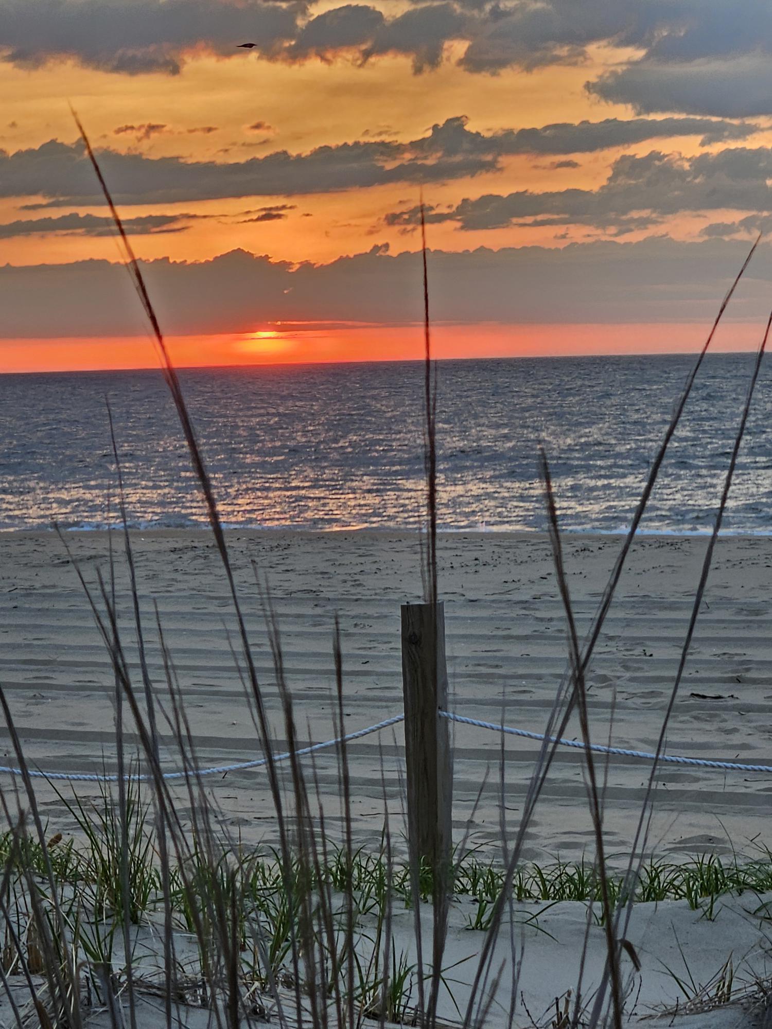
Along the way, I suddenly realized that I had the opportunity to get pictures of the sunrise over the Atlantic Ocean if I got to Ocean City in time. I was still disappointed about the missed opportunity while in Florida last December and wanted to take advantage of this unexpected chance. As it worked out, I found a public access to the beach just in time to see the sun’s appearance over the horizon. The beach was quiet at that time of the morning, so I was able to get several clear shots, one pictured here and the rest on my page at https://singin1.pics/piwigo/index.php?/category/Seein-the-DMV-Ocean-City-Assateague-Island-050125.
I’m not especially into beaches, so I headed to breakfast in the hope of beating the morning rush–which I barely did. Ocean City seemed very much like other similar towns-very tourist-y with large hotels taking up as much of the oceanfront beach as possible and lots of souvenir/tour-related shops and local food spots lining the main road. My timing was excellent because the streets and shops still only had light traffic, reflected throughout the trip. I reached the pickup point for my boat tour with two hours to spare.
 The 2.5-hour boat tour–OC Bay Hopper-Assateague Island Cruise–that I scheduled through Viator, had a primary goal of providing views of the feral horses that inhabited the island. The boat used was a motorized covered flat boat. When I saw the boat, I knew immediately that taking Have-Seat-Will-Travel-Too (my walker) would be a hindrance to boarding and sitting on the boat. As it worked out, I had to call upon the assistance of the captain and some of the four people on this excursion to climb on and off the boat. Sorry, but when someone claims accessibility these days, I must call them on it if the claim is not completely accurate.
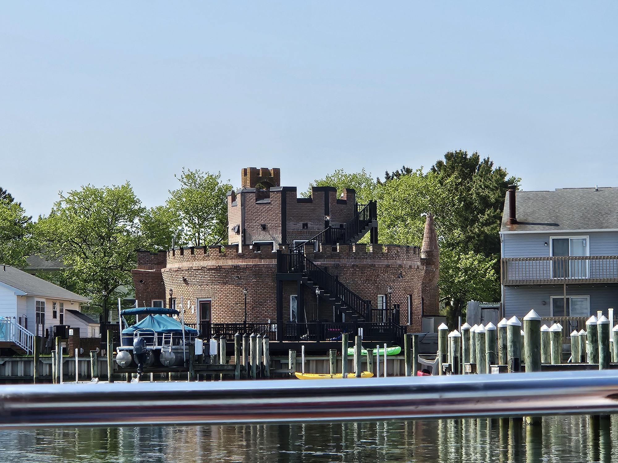
Other than a chilly ride when the boat powered up to speed along the Chincoteague Bay, the trip was an enjoyable way to spend the morning. The captain was friendly and clearly knew how to handle the boat, plus he had a wealth of knowledge about the waters, the water fowl (see osprey and its nest pictured in the set below) and the sites along the way–including this house built to resemble a medieval castle. He also mentioned that the area was site for the world’s largest marlin fishing competition, with first prize typically in the $4-7 million range. The one thing he could not control was the presence (or lack thereof in this case) of the horses on Assateague Island. I was able to get pictures of some of the birds he called to our attention, and I captured some of the many interesting houses built on the coast of the bay. As we finally returned to the dock, he suggested that those who had the time might drive over to the island and seek out horses that way.
Well, why not? I had the time and my handy dandy NP senior pass!


So, with the recommendation of the Hopper’s assistant (sorry I don’t have a more accurate description), I first stopped for lunch at Hooper’s Crab House. I chose to go to their smaller serving area, Sneaky Pete’s, because it sat directly on the water. The pictures above are of Hooper’s I took during the tour and of my view of the bay while sitting in Sneaky Pete’s. The negatives first: while I had no difficulty rolling Have-Seat-Will-Travel inside, they had no accessible seating, and the restroom outside Sneaky Pete’s had no grab bars inside the single stall (both easily fixable challenges). On the positive, the service was excellent, and I must especially compliment the young man who waited on me during lunch for his courtesy and attentiveness. My fish and chips were served quickly with a requested house old bay seasoning that added a nice kick to the meal. The Key lime pie I ordered to go was good, but I’ve had it from the source and know what real Florida Key lime pie should taste like. I don’t fault the effort. If I happen that way again, I most assuredly will return.
Assateague Island is a 37-mile-long barrier island located between Virginia and Maryland. It was once inhabited by human residents, but the island’s exposure to the violent storms that occasionally come from the Atlantic caused the federal government to purchase them out and eventually leave the island to the feral horses that roam it. The Maryland half of the island now has parks managed by the state and the National Park Service as the Assateague Island National Seashore.
I spent a quiet afternoon looking for horses without success initially–although I kick myself for not taking a picture of a group of them standing by the park sign, but the traffic didn’t really allow it at the time. I stopped several times along the way, sitting inside the Silver Bullet reading my kindle and hoping that a horse or two would stroll by. I actually finally hit the horse bonanza as I was leaving in the evening and got some pictures, including the post’s featured picture.
As usual, I’ve placed a sample of pictures below, with the reminder on my pictures page at https://singin1.pics/piwigo/index.php?/category/Seein-the-DMV-Ocean-City-Assateague-Island-050125.

As always, I thank the Lord for granting me the stamina to make the trip, the damn good reflexes to steer the Silver Bullet (SB) as she needed to be guided, and the ability to enjoy His handiwork as it whizzes by my windshield.
By the time I started my drive back home, the evening had transitioned to night, and the traffic allowed me to make good time to the Bay Bridge and on Rt. 50 to the Beltway, which at least wasn’t stop and go.
Over all, a really good 21-hour-long trip!
Midwest 2025 Update
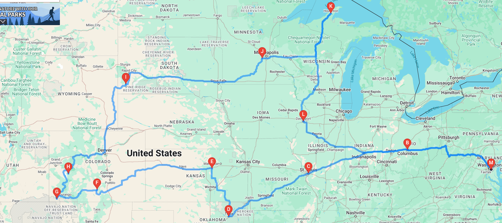
After assessing my trip to Midwest USA, I realized that driving from Tulsa to Michigan, while probable, might not be necessary. I was able to move the trip to Isle Royale National Park from Monday to Friday, which allowed me to not only get Wind Cave NP into my itinerary while I would be that relatively close by, but to add the three Colorado national parks (Great Sand Dunes, Mesa Verde, and Black Canyon of the Gunnison) and Paisley Park, the museum tribute to musician Prince, within those four extra days. Below is the new map, based on those changes:
Now, let’s see how close to this plan the actual trip is. So looking forward to it!
Discover more from Singin' One's Journeys
Subscribe to get the latest posts sent to your email.